

Hurricane Milton Went from Zero to Category 5 in Hours—And It Could Happen Again

Over the past few days, the residents of Florida have faced the devastating impact of Hurricane Milton.
This category-five hurricane has so far claimed more than 14 lives and injured many others.
This number is likely to rise as rescue workers continue their efforts across the state, assessing the damage to communities and infrastructure.
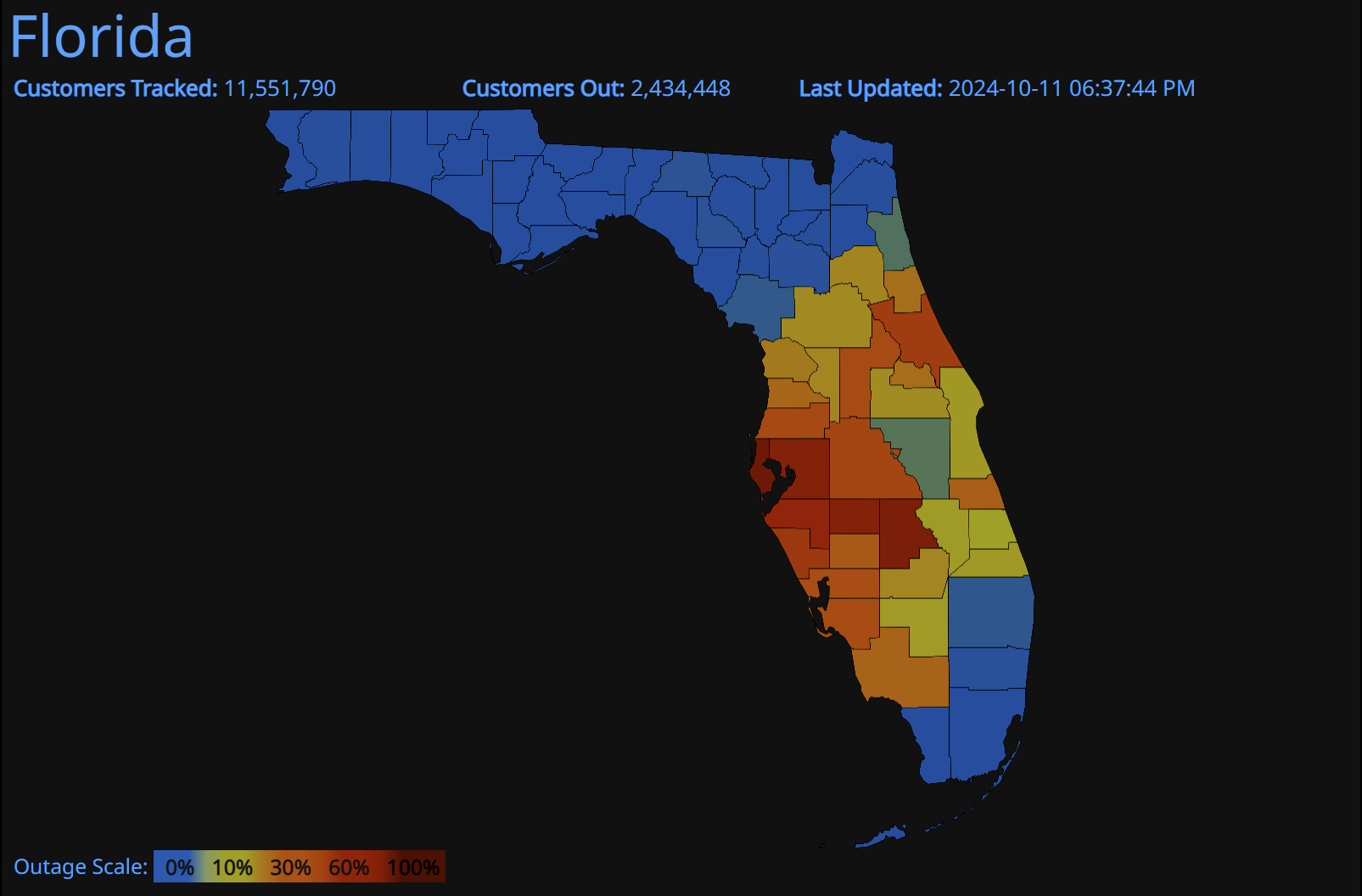
Hurricane Milton struck Florida at a time when the state was still recovering from the aftermath of Hurricane Helene, which made landfall just two weeks ago. As of now, over two million customers are still without power.
Strongest Late-Season Hurricane
This is the second hurricane to make landfall in Florida within two weeks and the third in this hurricane season.
Before this, Florida was hit by Debby in early August and then by Hurricane Helene at the end of September, which made landfall in the Big Bend area, claiming more than 200 lives across six states in the US.
Milton has been classified as the strongest late-season hurricane to hit the region. But what makes this storm especially noteworthy is how quickly it intensified.
How did a tropical depression turn into a supermassive category 5 hurricane in just a few hours? The answer lies in rapid intensification.

When a tropical storm's maximum sustained wind speed increases by more than 35 MPH within 24 hours, it’s termed as rapid intensification. Hurricane Milton has set new records in this regard.
On October 5th, it was still considered a tropical storm in the Gulf of Mexico. Just 24 hours later, it reached Category 1 status, and in the next 15 hours, it exploded into a powerful Category 5 hurricane.

Now, Milton holds the record for the fastest intensification of any Atlantic storm, with sustained winds surging from 35 MPH to 160 MPH in just over 48 hours, according to NASA.
But what drives a tropical depression to undergo such explosive growth?
Here are three reasons:
1. Warm Oceans
Any hurricane can rapidly intensify when it encounters the right conditions, and warm ocean water is key. Tropical storms form where sea surface temperatures are higher, giving them the energy to grow.

As seen in the chart, sea surface temperatures in the Gulf of Mexico are hovering around 30°C, 1.5°C above the average for the 1999-2020 period.
The storm follows the path of warm surface water, gaining strength as it moves. Once the storm makes landfall, it begins to weaken due to the lack of this warm water.
However, if deeper layers of ocean water are also warm, the storm can continue to feed off this energy, potentially turning into a devastating category 5 hurricane, as Milton did. In this case, the ocean heat content (OHC) played a significant role.

Ocean heat content measures the total thermal energy stored from the sea surface to ocean depths. It’s an indicator of how much fuel a storm has available as it strengthens.
The OHC in the Gulf was above the ten-year average, providing a critical source of energy for Milton.
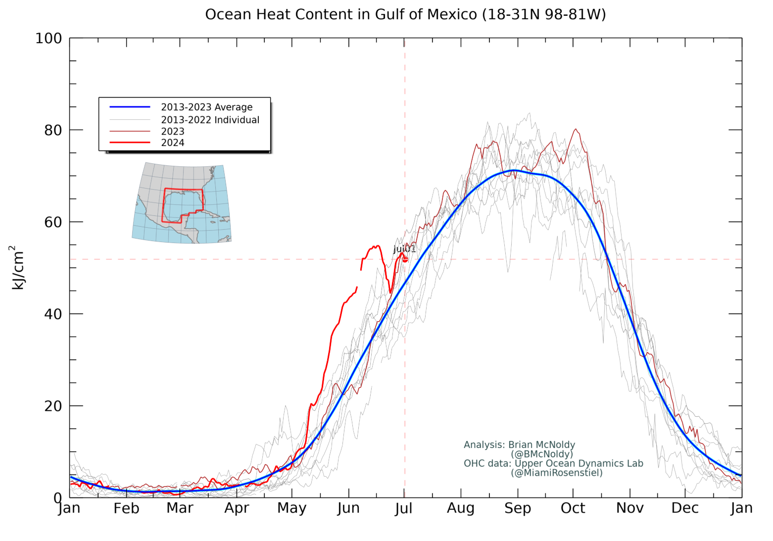
Senior research Brian McNoldy at the University of Miami had hinted at the high OCH levels right before Helene in a post he made on X.
He wrote - The ocean heat content in the Gulf is extremely high, particularly inside the Loop Current, which future-Helene will pass over. The area-average value is obliterating previous values for the date.

2. Low Wind Shear
Wind shear refers to changes in wind speed and direction at different levels of the atmosphere. Strong wind shear can disrupt a storm's structure, weakening it. Conversely, low wind shear allows a storm to remain organized and strengthen.
Zachary Handlos, an atmospheric science educator at the Georgia Institute of Technology, explains that hurricanes thrive when their vertical structure remains symmetrical, allowing the storm to rotate faster.
Low wind shear helped Hurricane Milton maintain this ideal structure, fueling its rapid intensification.
3. High Moisture Levels
Tropical storms depend heavily on moisture from warm ocean waters. Higher sea surface temperatures and lower salinity levels contribute to this.
When salinity is lower, heat remains trapped near the ocean surface, leading to more moisture being available for evaporation.
This constant supply of moisture allows the storm to grow stronger.
In Milton’s case, the combination of warm water, high moisture, and low wind shear created the perfect storm for rapid intensification.
What Next?
Now, the question is - will the frequency of storms going through rapid intensification keep on increasing?
The answer is - yes, more tropical storms are likely to rapidly intensify because the sea surface temperature and ocean heat content are at a record high.
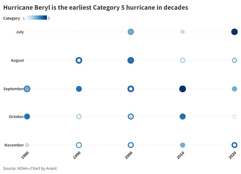
This season started with hurricane Beryl which was the earliest category 5 hurricane in many decades.
Hurricane Milton has already become the strongest late-season hurricane. Now, it is yet to be seen if it remains one or not.
Further Readings:
When a Television Meteorologist Breaks Down on Air and Admits Fear
Helene has become one of the deadliest hurricanes of the modern era
See the Ocean Heat Fueling Hurricane Milton, in One Chart
Milton Was an Impressive Storm. Here Are 5 Things Our Meteorologist Noticed.
The four most interesting weather phenomena during Hurricane Milton